Government & Transportation
Whether you manage state highways, transit networks, or city parcels, public agencies must justify budgets, comply with regulations, and respond to information requests— all while staff rotate and projects span fiscal years. ChronoCards captures detailed ArcGIS Pro activity so local, state, and federal GIS teams can deliver accurate data faster and prove the value of every geospatial hour.
Meet mandates, shorten reporting cycles, and safeguard institutional knowledge even when staff change.
Book a Live DemoSolutions for Public Sector Needs
Retain Knowledge Across Staff Rotations & Vacancies
Personnel changes shouldn’t wipe out hard-won know-how. ChronoCards captures every decision and action so incoming staff can pick up right where the last analyst left off.
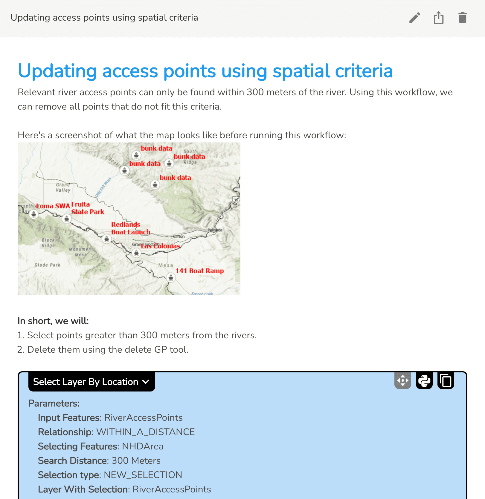
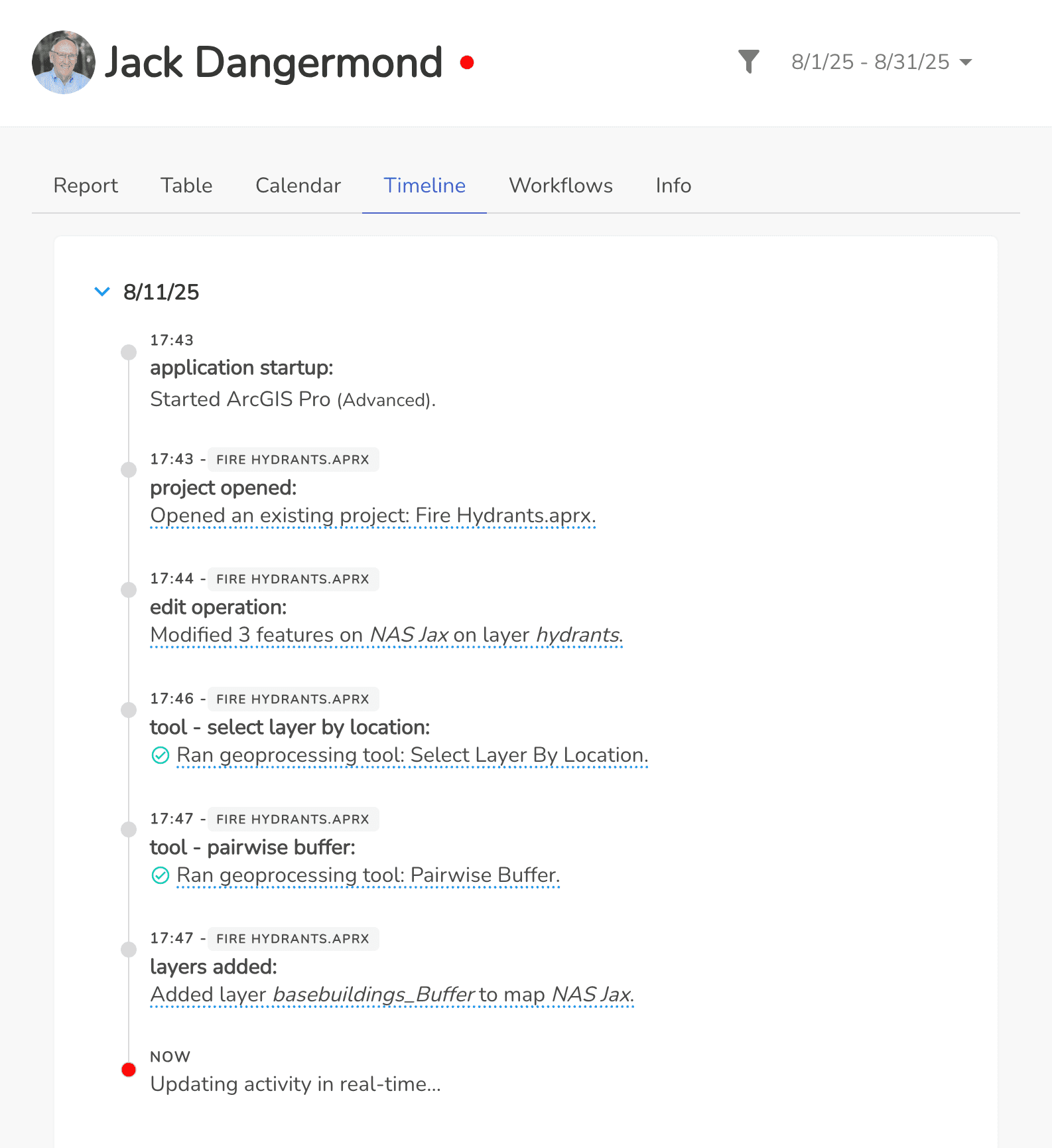
- Auto-log edits, geoprocessing tools, and parameters for a complete activity timeline
- Notes and screenshots preserve the how and why behind every analysis
- Bundle selected log items into sharable process documents or no-code Python notebooks
Seamless handoffs keep projects moving even when people move on.
Keep Annual Reports & Grant Submissions on Schedule
Recurring deliverables like state reports, federal grants, or database updates demand strict method consistency and punctual execution. ChronoCards records each action and surfaces real-time status so you never scramble at the eleventh hour.
- Monitor completion by user, dataset, or project to flag delays early
- Save approved workflows as reusable templates that new analysts can run in minutes
- Export full documentation packets for regulators, funders, or internal QA/QC
Repeat proven workflows, satisfy auditors, and hit every deadline with confidence.
Defend Budgets & Optimize Resources with Hard Numbers
Justifying staff and capital for road inventories, safety studies, or transit redesigns can stall without concrete evidence. ChronoCards converts everyday GIS activity into clear, finance-friendly metrics that back up every funding request.
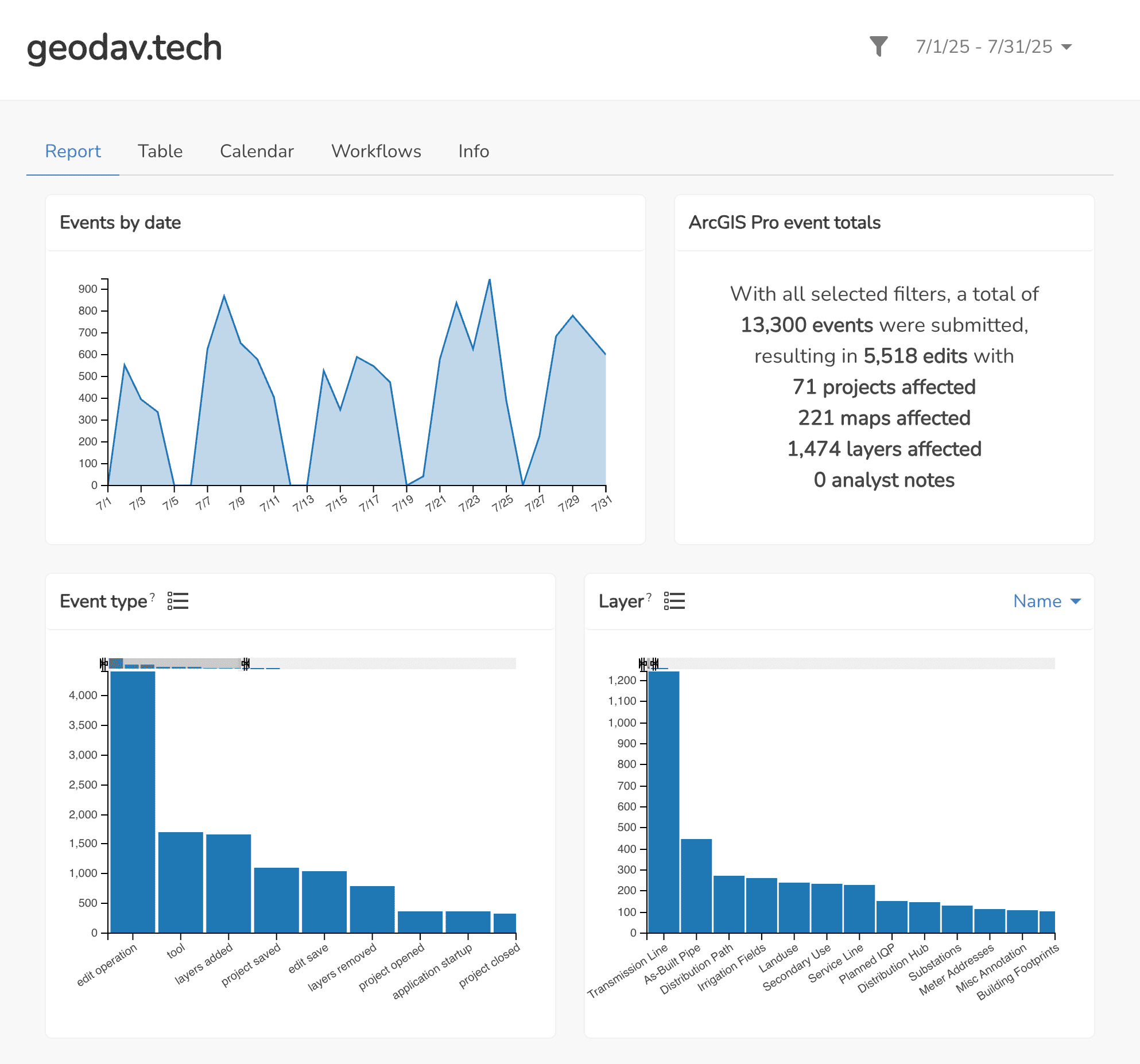
- See total hours and edit counts by project, team, or dataset
- Calculate true cost per task to strengthen budget narratives
- View interactive reports with charts for grant applications, asset plans, or executive briefings
Show the data, secure the dollars, and deploy resources where they drive the most value.
Shorten QA/QC & Interagency Coordination
Projects stall when reviewers wait for status updates or dig through email chains. ChronoCards streams every edit and geoprocessing step to a live dashboard, giving all parties immediate visibility into progress and potential issues.
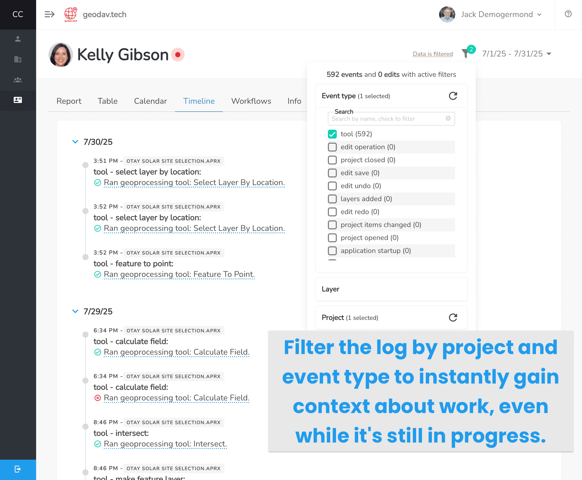
- View GIS activity in real time— no screen-sharing required
- Filter by user, layer, or project to pinpoint discrepancies in seconds
- Read inline notes and screenshots for instant context during peer review
- Export annotated logs to share with external partners
Catch errors early, keep everyone aligned, and push projects across the finish line faster.
Be Audit-Ready for FOIA, Geospatial Data Act, & Internal Reviews
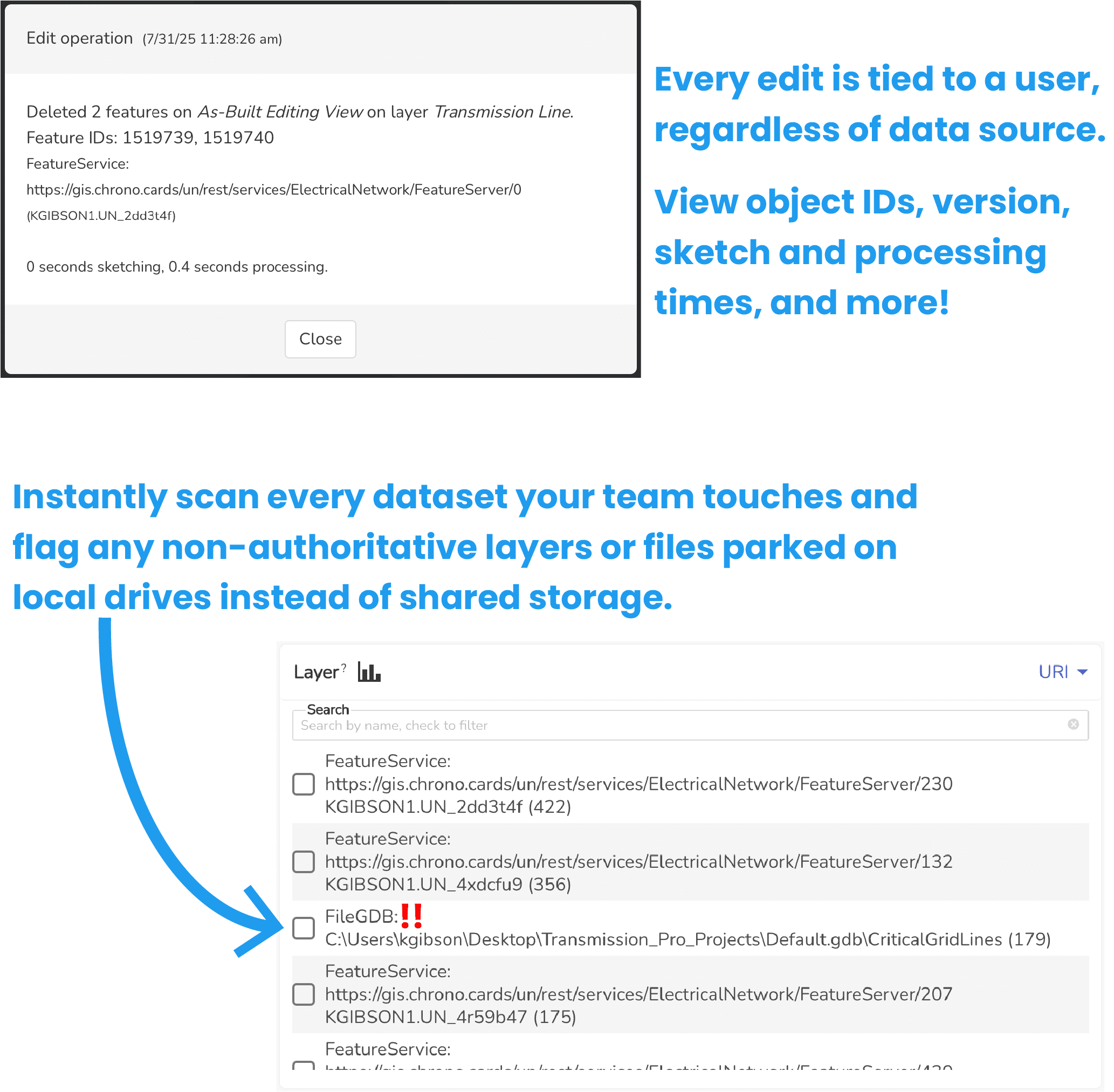
Transparency mandates can strike at any time, demanding proof of data lineage and performance. ChronoCards keeps a tamper-proof record of every action so you can answer data lineage or performance questions in minutes, not weeks.
- Log every edit, geoprocessing tool, and parameter with second-by-second time stamps
- Generate proof of data lineage with a one-click CSV export
- Trace each change back to the exact user, project, and SDE/branch version
With immutable lineage logs at your fingertips, you’ll sail through any audit with confidence.
Why Government & Transportation Teams Choose ChronoCards
| Pain Point | ChronoCards Solution |
|---|---|
| Yearly reports and submissions require repeatable workflows | Workflow documents capture approved methods so staff can reproduce results exactly. |
| Limited visibility into contractor and partner progress | Real-time activity logs show progress across agencies and vendors. |
| Staff turnover causes knowledge gaps and delays | Analysts’ work and process history is logged automatically, enabling replacements to resume work immediately. |
| Audits and public requests demand detailed lineage | Exportable, immutable logs provide time-stamped evidence of actions taken against your data. |
| Difficulty quantifying GIS workload and justifying budgets | Analytics dashboard surfaces hours, tool usage, and edits by project and user, enabling you to quantify your team’s GIS efforts and forecast future needs. |

Typical Government & Transportation Outcomes
- Up to 30% faster completion of annual reports when documented with ChronoCards
- 40% faster onboarding of new analysts & subcontractors; with greater transparency and less frustration
- 6× ROI by eliminating just 15 minutes/day of manual documentation
- Instant insight into project status across your team and contractors

IT Approved
ChronoCards works out-of-the-box with your existing environment. No IT changes required!
- Compatible with ArcGIS Pro 3.1+ (2.8 & 2.9 supported with limited features)
- Nothing replicates your GIS data; only metadata & object IDs are stored
- Fully supports branch or SDE versioning and Utility Network datasets
- Cloud platform hosted on Microsoft Azure in U.S. data centers
- Self-hosted edition may be available depending on your needs
Need more technical details? Visit the features pages or dive into the FAQ.